Dorasan and Third Tunnel
도라산과 제3땅굴

Helmets to prevent visitors from smashing their skulls against the tunnel of agression’s ceiling (November 2024).
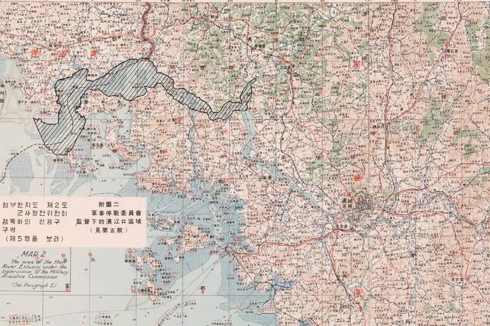
The Dora observatory is on the itinerary of many ‘DMZ Tours’ starting from Seoul. As it is located inside the Civilian Control Zone, it is not accessible to individual travelers. The only way to get here for ordinary people is to be part of an organised group. All Dorasan tours include a visit to Imjingak, the nearby “Third Tunnel of Agression” and a “DMZ souvenir shop” in the Unification Village.
Due to the pressure of turnover most visitors are rushed out of the place by their stressed-out guides before they can appreciate its true value. The stop at the observatory can last anything from ten minutes to an hour, depending on the mood of the guide and whether you’re ahead or behind schedule.
Despite these drawbacks, Dorasan remains an extraordinary place. It’s the only point in the South from which you can get a close-up view of a major North Korean city, Kaesong.
Unfortunately, after decades of permissiveness and for some unknown reason, it is now strictly forbidden to take photos in Dorasan.
Combined with the haste with which organized tours usually stop here before heading to the souvenir shop, this prohibition is frustrating. Visitors are led into a huge amphitheater and, excluding periods of military tension, onto a rooftop with jaw-dropping views of North Korea and breathtaking landscapes their retinas won’t soon forget.

A gentle reminder of where you are (November 2024).
But a nervous military minder, usually a conscript entrusted with a mission completely beyond his control, will do his best to keep tabs on the hundreds of noisy and unruly foreigners who pass through here every hour and will pounce on anyone attempting to take a selfie.
At best, offenders caught red-handed get away with a yelling, an erased memory card and a stern warning to their tour guide. Signs everywhere remind that taking photos of “military installations” (a term that, near the DMZ, applies to everything from strategic radar stations to road signs and rusty barbed wire) is punishable by three years in prison and a hefty fine. I doubt this draconian law has ever been applied to naive tourists and photographers, but I’d hate to be the first to disprove that doubt.
Tour guides now console their frustrated customers with their own photos taken from Dorasan back in the days when it was allowed. So don’t be surprised to find on social networks the same image signed by a thousand different people – all except the real author.
The images I publish here were taken in 2023, when photography was still legal. Here is what you see from Dorasan:
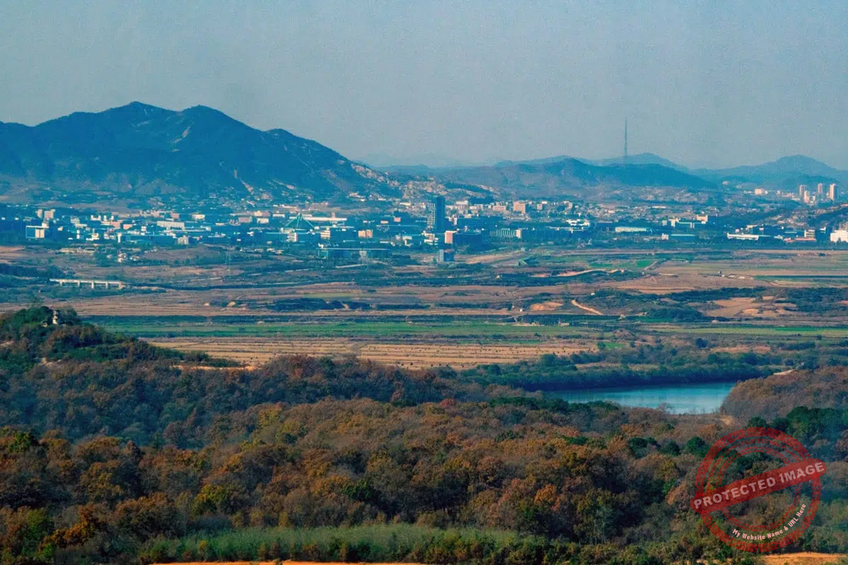
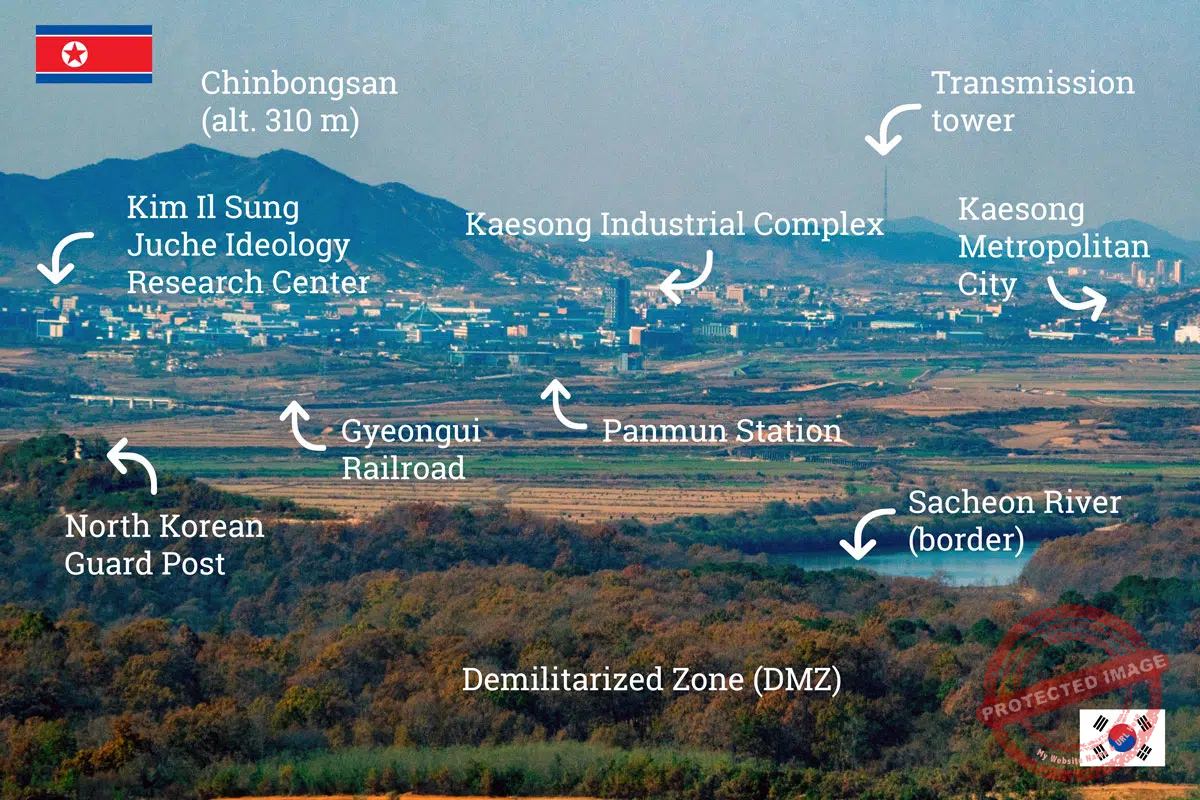
The North Korean city of Kaesong seen from the Dora Observatory, in South Korea (November 2023).
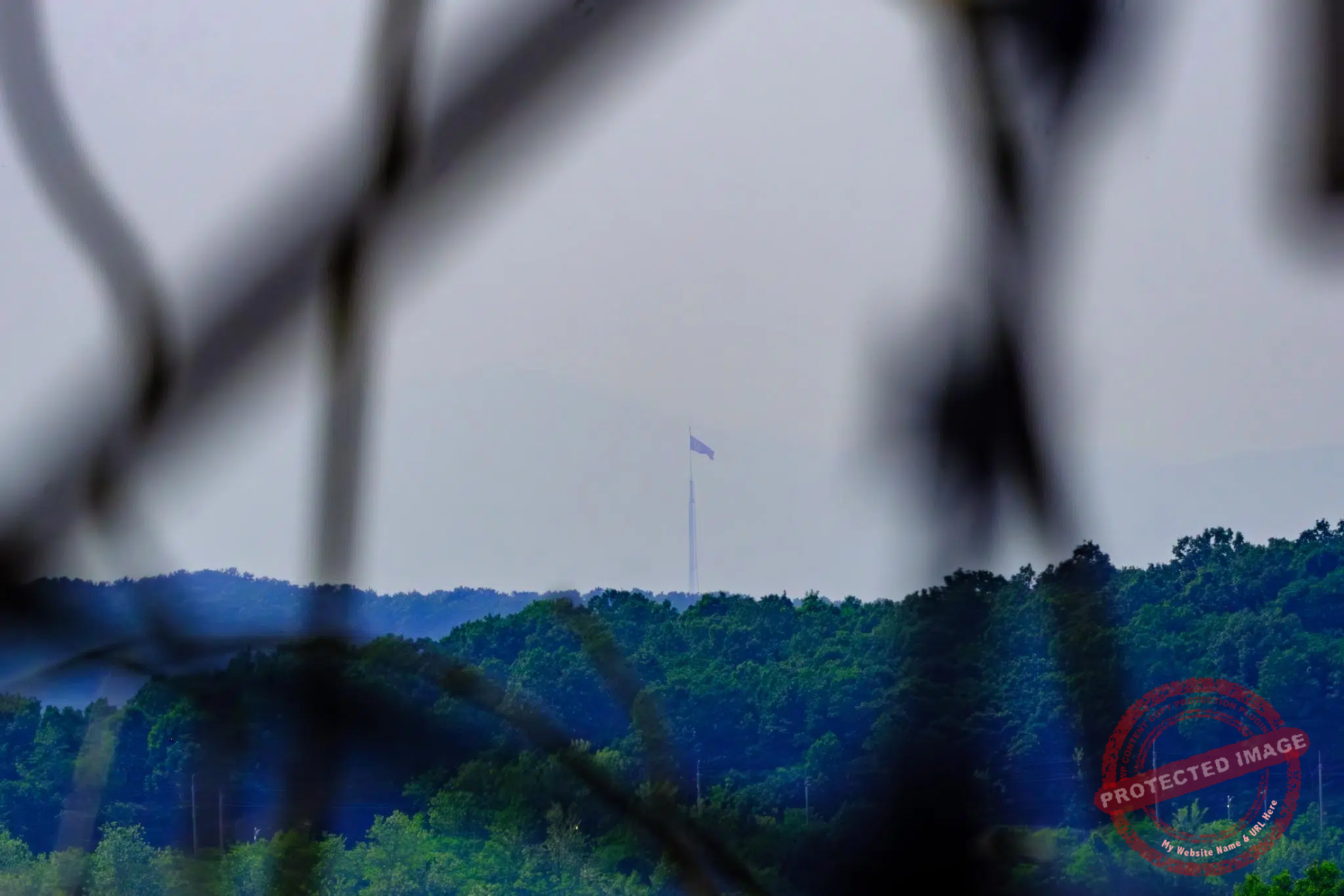
Transmission tower: located on the top of mount Yongsu, this 266 meter-high tower is used to jam South Korean GPS signals (causing occasional disruption to air traffic around Seoul-Incheon airport, which is just a few dozen kilometres away. It also blocks radio and TV waves to prevent the North Koreans from hearing or watching South Korean broadcasts.
Kaesong Industrial Complex (KIC): This project was launched in December 2004, largely financed by South Korea to increase co-operation with its neighbor while allowing South Korean companies to employ cheap labour from the North.
Up to 124 South Korean companies settled there, employing more than 54,000 North Korean workers and hundreds of South Koreans. All goods produced at the KIC, from textile and leather to electronics, chemicals and machinery, were exported to the South. Although both governments were involved, this was a private venture led by the Hyundai Group. The complex also included a hospital, a sewage treatment plant, a branch of South Korea’s Woori Bank and even a Family Mart convenience store. KIC’s South Korean staff were ferried by bus from Dorasan.
During 11 years, the KIC survived several administration changes in Seoul, a series of severe military incidents at the border or at sea and a five month-long shutdown in 2013. In February 2016, South Korea’s president Park Geun-hye unilaterally closed the complex, asserting that Pyongyang was using money from it to fund its nuclear weapons and balistic missiles programs.
In June 2020, the North Koreans blew up the former Inter-Korean Joint Liaison Office in the KIC after South Korean groups sent balloons loaded with propaganda leaflets and flash drives containing k-pop music and k-dramas into North Korea.

The disused South Korean checkpoint on the road to the Kaesong Industrial Complex, about 2.5 kilometers south of the inter-Korean border and 500 meters from the DMZ’s Southern Limit Line (November 2024).
Panmun Station: This station is located on the Gyeongui railway line, which before the Korean war linked Busan to Sinuiju, on the Chinese border, via Seoul and Pyongyang. The station, as well as the disused rail section from Kaesong across the DMZ to Dorasan, was rebuilt in 2003. A special train inaugurating the reopened line ran in May 2007. Regular freight service briefly linked the South and the Kaesong Industrial Complex but were suspended amid tensions the following year.
In 2018, at a time of détente in North-South relations, a train carrying 28 South Korean engineers crossed the border for the first time in a decade. During 18 days, the experts inspected 1,200 km of tracks and other infrastructure in North Korea as part of a project to help the country modernise its rail network.
In October 2024, North Korea carved at least two large trenches across roads and rail lines on its border with the South, a month after blowing up the northern sections of cross-border routes.
Kaesong City: Kaesong served as the capital of the Koryo Dynasty (918–1392), a unified Korean kingdom, and is home to several UNESCO World Heritage Sites including the Koryo-era royal tombs and the Confucian academy (Sungkyunkwan).
Located south of the 38th parallel, which divided the Korean Peninsula between the Soviet-occupied North and the United States-occupied South following World War II, Kaesong was initially part of South Korea. After changing hands several times in 1950, during the first six months of the Korean War, the city was recaptured by North Korean and Chinese forces on New Year’s Day 1951 and has remained under North Korean control ever since. It is now North Korea’s 7th largest city with an estimated population of 310,000.

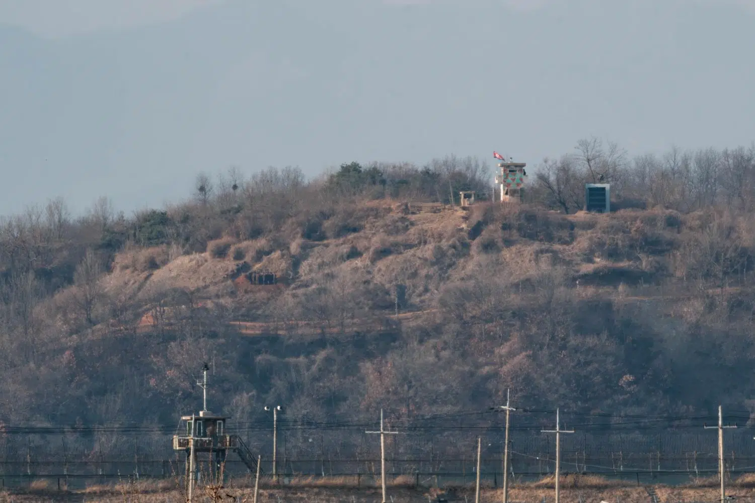
Tourists watch North Korea from the Dorasan Observatory (March 2023).
Military Demarcation Line (MDL): There are no fences or walls to materialize the inter-Korean border. The 248 kilometers long MDL is marked off since 1953 by a series of 1,292 identical signs across the peninsula. The north facing sides are written in Korean and Chinese. The south facing sides are written in Korean and English. But in fact, due to rust and lack of maintenance for over seven decades, most signs have become virtually impossible to read.
Kim Il Sung Juche Idea Research Center: Little is known about this facility. Juche (주체사상 – juche sasang) is the official ideology and quasi-religion of the Democratic People’s Republic of Korea (DPRK). It was introduced by the country’s “eternal president” Kim Il Sung as a variant of Marxism-Leninism, and transformed by his son and successor Kim Jong Il who emphasized the loyalty to the leader.
The North Korean constitution states that “the DPRK is guided in its activities by the Juche idea”. Juche is often described as a combination of self-reliance, nationalism and socialism, serving as the guiding principle for everything in the country, from governance and policies to arts, litterature, movies and even scientific research. It has justified North Korea’s isolationism, suppression of dissent and emphasis on the cult of personality surrounding its leaders.
Starting from elementary school, Juche is a central part of the curriculum in the North Korean education system, designed to indoctrinate students with the principles of the ideology and instill loyalty to the Kim family.
Students participate in songs, plays, and activities celebrating Juche and the Kims. They are tested on their understanding of Juche and the achievements of the leaders. Success in these subjects is essential for academic and career advancement. Juche shapes the worldview of North Korean citizens from an early age, promoting conformity and loyalty to the regime.
"Third Tunnel of Agression"

Foreign tourists and South Korean soldiers arrive at the entrance of the “Third Tunnel of Agression” (November 2024).
Along with Dorasan and Imjingak, the ‘Third Infiltration Tunnel’, also called ‘Third Tunnel of Agression’, is one of the busiest tourist attractions of the border area. Located 1.2 kilometres from the demarcation line, this tunnel is technically inside the DMZ as defined by the armistice agreement. Like Dorasan, it can only be reached on an organised tour.
It is one of four known tunnels dug by North Korea under the border with the aim of launching a surprise invasion of the South, the closest to Seoul and, as its name suggests, the third to have been discovered. That happened in October 1978, after the South Korean military heard mysterious explosions coming from underground.
Based on intelligence and on defectors accounts, it is estimated that that there are around twenty more North Korean infiltration tunnels that have never been discovered, and are virtually impossible to detect.

DMZ selfie spot near the entrance of the “Third Tunnel of Agression”, located about 1.2 km from the border (November 2024).
The tunnel is 1,635 metres long, 1.95 meters at its maximum height and 2.1 meters wide. Like its equivalent in Cheorwon, the Third Tunnel would have allowed for 30,000 soldiers to pass through per hour. It had been blackened by construction explosions, and North Korea pretended it was part of a coal mine, although it is geologically impossible to find coal in this granite soil.
A long and steep inclined gallery (or sometimes a monorail) takes visitors, provided with helmets to prevent them from smashing their heads against the rocky ceiling, to 73 metres below the surface of the DMZ. Photography is forbidden within the tunnel. Visitors must leave their mobile phones and cameras in a locker and pass through a metal detector before going down.
The South Korean Army has blocked the tunnel near the Military Demarcation Line with three concrete barricades. Tourists can walk as far as the third barricade. The second barricade is visible through a small window in the third.

Tourist take pictures with fake South Korean soldiers at the entrance of the 3rd infiltration tunnel (November 2024).
This post was last updated on : June 19, 2025